


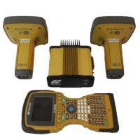
Leica Viva GNSS GS08 Plus Receiver
The Leica Viva GNSS GS08 Plus Receiver is a high-performance GPS/GNSS receiver designed for precision surveying and geospatial applications. It is part of the Leica Viva series, which includes advanced equipment for professionals in surveying, construction, and mapping.
Features:
- Multi-GNSS Support:
- The GS08 Plus is capable of tracking multiple GNSS constellations including GPS, GLONASS, Galileo, BeiDou, and QZSS. This allows for enhanced positioning accuracy, especially in challenging environments with poor satellite visibility.
- Real-Time Kinematic (RTK) Capability:
- The receiver supports RTK technology, providing high-precision positioning in real time. RTK is commonly used for surveying applications where centimeter-level accuracy is required.
- High-Precision Performance:
- The GS08 Plus delivers high-precision performance for applications such as land surveying, geodesy, and construction. It can achieve accuracies down to the centimeter level under ideal conditions.
- Compact and Rugged Design:
- The receiver is designed to be lightweight and durable, with an IP67 rating for dust and water resistance. This makes it suitable for use in harsh field conditions and tough environmental situations.
- Advanced Antenna Technology:
- The GS08 Plus features an integrated GNSS antenna, optimized to enhance signal reception in both open and obstructed environments (e.g., under tree canopies or in urban canyons).
- Flexible Communication Options:
- It supports a variety of communication methods, including Bluetooth, UHF radio, and cellular connections, for data transfer and remote operation.
- Long Battery Life:
- The receiver is equipped with a long-lasting battery, which helps extend field operation time, crucial for demanding surveying projects.
- Leica SmartWorx Software:
- The receiver integrates seamlessly with Leica SmartWorx software, which provides intuitive, easy-to-use interfaces for field data collection and processing. SmartWorx also allows for enhanced productivity, error reduction, and real-time quality control.
- Positioning and Post-Processing:
- Besides real-time applications, the GS08 Plus can also be used for post-processed kinematic (PPK) solutions, allowing for high-accuracy corrections after data collection.
Applications:
- Land Surveying: Professional surveyors use the GS08 Plus for boundary surveys, topographic mapping, construction staking, and more.
- Engineering and Construction: Used in construction projects for machine control, as-built surveys, and civil engineering applications.
- Geodetic Networks: It can be used for establishing and maintaining geodetic networks, with high precision required for national or regional network setups.
- GIS Data Collection: Ideal for gathering accurate geospatial data for geographic information systems (GIS) mapping and analysis.
Benefits:
- Enhanced Productivity: The GNSS receiver’s real-time data processing capabilities improve workflow efficiency and reduce the time needed for field data collection.
- Accuracy and Reliability: It provides high-accuracy results, even in areas with challenging satellite visibility, thanks to its multi-constellation tracking and advanced signal processing.
- Flexibility: With multiple communication options and compatibility with various software solutions, the GS08 Plus adapts well to different surveying environments.
General Specifications:
- GNSS Constellations Supported:
- GPS (L1, L2, L2C, L5)
- GLONASS (L1, L2)
- Galileo (E1, E5a, E5b)
- BeiDou (B1, B2, B3)
- QZSS (L1, L2, L5)
- SBAS (WAAS, EGNOS, MSAS, GAGAN)
- Signal Tracking:
- 555 tracking channels (dual-frequency tracking)
- Supports L-band (satellite-based augmentation systems, SBAS)
- Accuracy:
- RTK (Real-Time Kinematic):
- Horizontal: < 8 mm + 1 ppm
- Vertical: < 15 mm + 1 ppm
- Static (Post-Processing):
- Horizontal: < 2 mm + 0.5 ppm
- Vertical: < 4 mm + 1 ppm
- RTK (Real-Time Kinematic):
- Data Communication:
- UHF Radio: Supports up to 30 W output power (depending on region)
- Bluetooth®: For wireless communication with field controllers
- Cellular/GPRS: For real-time corrections and data transmission
- Internet (Wi-Fi or Ethernet): For remote access and data transfer
- Measurement Modes:
- RTK (Real-Time Kinematic)
- PPK (Post-Processed Kinematic)
- Static and Fast Static modes for high-accuracy surveys
- Differential GNSS (DGNSS)
Hardware Specifications:
- Antenna:
- Integrated GNSS Antenna with high-performance multi-frequency capabilities
- Supports all GNSS constellations for enhanced signal reception
- Antenna Type: Active multi-frequency antenna with a wide-band receiver
- Power Supply:
- Battery Type: Li-ion rechargeable battery
- Battery Life:
- Up to 12 hours under typical operating conditions
- Longer runtime with external battery packs (optional)
- Operating Temperature:
- -40°C to +65°C (-40°F to +149°F)
- Storage Temperature: -55°C to +85°C
- Water and Dust Resistance:
- IP67 Rating: Waterproof and dustproof
- Fully protected against immersion in water up to 1 meter deep for 30 minutes
- Dimensions:
- Height: 10.4 cm (4.1 inches)
- Diameter: 23.0 cm (9.1 inches)
- Weight: 1.2 kg (2.65 lbs) with battery
- Sensor Technology:
- Dual-antenna support for precise heading, positioning, and accuracy in difficult environments (such as on moving platforms)
Software Integration:
- Leica SmartWorx:
- SmartWorx software for efficient data collection and real-time corrections
- Provides intuitive user interface for surveyors
- Compatibility with Leica Captivate for seamless field-to-office integration
- Leica GNSS Spider:
- Used for creating and maintaining GNSS reference networks
- Provides post-processing support and network corrections
Advanced Features:
- Multi-frequency Support:
- Supports L1, L2, L2C, L5, E1, E5, B1, B2, B3, QZSS, and SBAS frequencies for robust signal tracking and superior accuracy
- Enhanced performance in challenging environments like urban canyons, forests, or mountainous areas.
- RTK Network Compatibility:
- Supports both RTK Base/Rover and Network RTK configurations
- Leica SmartNet: A global RTK network for real-time corrections.
- Field Data Communication:
- Supports RTK, GNSS Data Logging, PPK data transfer, and real-time kinematic corrections over mobile networks or UHF radio.
Optional Accessories:
- Leica CS20/CS35/CS60 Field Controllers: Integrated with Leica SmartWorx for enhanced usability.
- External Radio Modems for extended communication range.
- External Power Packs: For extended field use.
Environmental Compliance:
- CE Marked
- RoHS Compliant: Free from hazardous materials as per European Union standards.


Reviews
There are no reviews yet.