

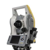
Topcon GLS-2000 3D scanner
Topcon GLS-2000 is a high-performance 3D laser scanner designed for various applications, including construction, engineering, architecture, and surveying. It offers advanced scanning technology, enabling detailed and accurate 3D data capture of complex environments.
- High-Resolution Scanning: The GLS-2000 can capture high-resolution scans with precision, which is crucial for creating accurate 3D models and conducting detailed analysis.
- Range and Accuracy: It has a long range, often up to 200 meters or more, depending on the scanning environment, and offers high accuracy (with errors in the millimeter range).
- Fast Data Capture: The scanner is designed for efficiency, allowing rapid data collection to speed up workflows on-site.
- Ease of Use: Topcon has focused on user-friendliness, and the GLS-2000 typically comes with software integration that makes it easier to process and manage the collected data.
- Versatility: It’s suitable for a wide range of surveying tasks, including building scanning, infrastructure projects, and even large-scale land surveying.
- Real-Time Data: The scanner can provide real-time feedback, helping operators verify data accuracy during fieldwork.
- Durability: Built to withstand tough environmental conditions, the GLS-2000 is often designed with IP-rated protection, which makes it resistant to dust and water.
Features and Benefits
- High Accuracy with Precise Scan Technology
- High Speed 360º Dome Scanning
- Long Range
- Dual Camera
- Eye Safe, Selectable Laser Technology
- Compact, Lightweight, Rugged Design
Fast, long-range laser scanners
The GLS-2000 Series includes three options of measurement range for short, medium and long distance applications. Choose from the GLS-2000S, ideal for short range applications with a high speed range of 130 metres, or the GLS-2000M for 350 metre range as standard, or alternatively the GLS-2000L for long range measurements up to 500 metres in standard mode.
Benefits:
- Selectable laser measurement modes from Class 3R – Class 1 to suit all job site conditions
- Multiple Lens Array System that quickly switches focal length settings
- Auto Temperature Adjustment for consistent accuracy through the project
- Precise Scan Technology –signal processing including wave form for the ultimate in precise data
- Compact, lightweight and rugged design
The one-touch scanner can deliver ”eye-safe” scanning range at an exceptional speed. The GLS-2000 can be put to work and provide quick results without compromising accuracy making it an ideal tool suitable to multiple applications. Project such as the ”Scan-to-BIM” and ”As-Built” will benefit greatly from the precision and productivity provided by the GLS-2000.
The GLS-2000 also features the 360° full dome scanning capability, which allows the more difficult structures such as building interiors, towers and bride spans can be recorded at the touch of a button.
The GLS-2000 is ideal for:
- Geopositioning
- Construction
- Topography & As Builts
- Civil Engineering & Design
- BIM
- Mining
- Utilities
- Forensics
General Specifications:
- Laser Type: Time-of-flight (ToF) laser scanning technology.
- Measurement Range:
- Maximum Range: Up to 200 meters (656 feet) for high reflectivity targets.
- Minimum Range: Approx. 1 meter (3.28 feet), depending on conditions.
- Measurement Accuracy:
- Typically ±4 mm at 25 meters (82 feet).
- Accuracy improves at shorter distances.
- Scan Speed:
- Up to 1 million points per second, depending on scan settings and conditions.
Field of View:
- Horizontal Field of View: 360°
- Vertical Field of View: 310°
Scanning Resolution:
- Offers a high level of detail for precise scanning, with configurable resolution options (for example, fine, medium, or coarse scan settings).
Data Storage:
- Internal Memory: 32GB internal storage (expandable).
- File Format: It can output point clouds in common formats like .PTS and .LAS, compatible with most 3D software.
Connectivity:
- Wi-Fi and Bluetooth: For wireless communication with external devices like tablets or PCs.
- USB Ports: For data transfer and external device connectivity.
Power Supply:
- Battery: Li-ion rechargeable battery (typically offers 8-10 hours of scanning depending on conditions).
- Battery Life: Can be extended with spare batteries or external power options.
Environmental Protection:
- IP Rating: Typically IP54 (dust and splash resistant).
- Operating Temperature: From -10°C to +50°C (14°F to 122°F), which makes it suitable for use in various environmental conditions.
Weight and Size:
- Weight: Around 4-5 kg (8.8-11 lbs), depending on the exact model configuration.
- Dimensions: Compact design for easy handling and transport.
Software Compatibility:
- Integrated Software: Compatible with Topcon’s software suite for data processing (like Magnet Collage) and also compatible with other 3rd-party software like AutoCAD, Revit, and Cyclone for data analysis and modeling.


Reviews
There are no reviews yet.