


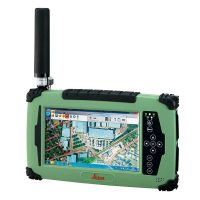
Leica GR50 Highline GNSS
The Leica GR50 Highline GNSS is a high-performance GNSS receiver designed for precision positioning and surveying applications. It supports multiple GNSS constellations, including GPS, GLONASS, Galileo, and BeiDou, which enhances its accuracy and reliability in various environments.
Features:
1. **Multi-frequency Support**: This allows for improved accuracy and reduced susceptibility to signal interference.
2. **Robust Design**: Built to withstand harsh conditions, making it suitable for fieldwork.
3. **User-friendly Interface**: Simplifies operation and data management.
4. **Flexible Connectivity**: Options for Bluetooth, Wi-Fi, and cellular communication for data transfer.
5. **Advanced Algorithms**: Enhances real-time positioning capabilities and minimizes errors.
Specifications:
1. GNSS Constellations:
– Supports GPS, GLONASS, Galileo, BeiDou, and QZSS.
2. Frequency Bands:
– Multi-frequency capability, typically L1, L2, L5 for GPS and similar bands for other systems.
3. Positioning Accuracy:
– Centimeter-level accuracy in RTK (Real-Time Kinematic) mode.
4. Data Logging:
– Internal memory for data storage, often capable of storing large datasets.
5. Communication:
– Supports various communication protocols (Bluetooth, Wi-Fi, LTE).
6. Power Supply:
– Typically powered by rechargeable batteries with extended operational times.
7. Weight and Dimensions:
– Compact and lightweight design for ease of transport.
8. Environmental Rating:
– IP67 rating, indicating resistance to dust and water immersion.
9. User Interface:
– Intuitive interface with optional display and remote access capabilities.
10. Software Compatibility:
– Compatible with Leica’s own software solutions for data processing and management.
GR50 Highline, GNSS Reference Server, 555 channels, multiple 1Hz native raw data logging and streaming including
RTK corrections;
Ethernet, Bluetooth, serial, slot-in module;
USB host & client interfaces;
on-board screen & keypad;
dual power input and slot-in battery; PPS out, event input and external oscillator port.

Benefits:
1. High-Precision Accuracy
- Centimeter-Level Positioning: The GR50 provides real-time centimeter-level accuracy, which is critical for tasks like land surveying, boundary mapping, construction layout, and geodetic applications.
- Multi-Constellation Support: By leveraging multiple GNSS constellations (GPS, GLONASS, Galileo, BeiDou), the receiver maximizes satellite signal availability and accuracy. This ensures more reliable data even in challenging environments with partial satellite visibility, such as urban canyons or forested areas.
2. Reliability in Challenging Environments
- Improved Signal Reception: The ability to connect to multiple satellite constellations helps mitigate issues such as signal interference or blockage. In situations where GPS signals alone might be weak or inconsistent, the GR50 can use alternative constellations like Galileo or BeiDou, providing more robust positioning.
- Enhanced Performance with IMU Integration: When paired with an Inertial Measurement Unit (IMU), the GR50 can continue to provide accurate positioning even when satellite signals are temporarily unavailable. This is particularly useful in dense urban environments, beneath tree cover, or when moving through obstructed areas.
3. Durability and Ruggedness
- Weatherproof Design: The GR50 is built to withstand harsh environmental conditions, including extreme temperatures, dust, moisture, and rough handling. It is ideal for outdoor use, providing reliability in diverse field conditions without worrying about equipment failure due to weather or physical stress.
- Long Battery Life: Its efficient power management system ensures longer working hours, reducing the need for frequent recharging and increasing productivity during long surveying sessions.
4. Real-Time Results (RTK Technology)
- Instant Accuracy with RTK: The GR50’s Real-Time Kinematic (RTK) capability enables real-time, high-precision corrections. Users can receive immediate, accurate position data while in the field without needing to post-process the data afterward. This feature is highly beneficial for construction teams, engineers, and surveyors who need quick and precise results for decision-making.
5. Efficiency and Productivity
- Faster Data Collection: With its high accuracy, multi-constellation support, and RTK capabilities, the GR50 allows users to collect data faster and with fewer corrections required. This means less downtime for recalibration and greater productivity in the field.
- Seamless Integration with Leica Ecosystem: The GR50 integrates well with Leica Geosystems’ hardware and software tools, enabling a smooth workflow from data collection to analysis and reporting. This reduces the complexity of managing multiple tools and platforms and streamlines project workflows.
6. Compact and Portable
- Lightweight Design: The GR50’s compact form factor makes it easy to transport and set up, which is particularly important for teams that need to move between multiple locations during a single day of surveying. Its ease of use and portability make it an ideal choice for professionals working in dynamic or remote environments.
7. Future-Proof Technology
- Support for New GNSS Signals: The GR50 is designed to be future-proof with support for upcoming GNSS signals (like those from the Galileo and BeiDou constellations), ensuring it remains useful as satellite technologies continue to evolve.
8. Cost Efficiency
- Reduced Need for Post-Processing: With RTK and high-precision positioning, the GR50 reduces the need for expensive post-processing equipment and software, cutting down on operational costs.
- Increased Project Turnaround: The GR50’s fast, accurate, and reliable results lead to quicker project completion times, which is an economic benefit for companies involved in large-scale construction, land surveying, and other time-sensitive projects.


Reviews
There are no reviews yet.