


Leica BLK360 Imaging Laser Scanner
Leica BLK360 is an advanced imaging laser scanner that captures high-quality 3D point clouds, panoramic imagery, and measurements to create detailed, accurate representations of physical spaces. It is widely used in industries like architecture, construction, engineering, and surveying.
Features:
- 3D Laser Scanning:
- The BLK360 uses a LiDAR (Light Detection and Ranging) sensor to capture millions of points in a 360-degree field of view, generating detailed 3D point clouds of the scanned environment.
- High-Resolution Imaging:
- It combines LiDAR scanning with high-definition imaging. The scanner takes HDR (high dynamic range) images, allowing for clear, detailed panoramic photos that can be overlaid on the point cloud data.
- Fast and Efficient:
- The BLK360 can scan a complete environment in just a few minutes, capturing both geometry and visual data simultaneously. This speed makes it a powerful tool for field surveying and documentation.
- Compact and Lightweight:
- Weighing only around 1 kg (2.2 lbs), the BLK360 is a portable, user-friendly device. Its small size makes it easy to carry to remote or tight locations, offering mobility without compromising performance.
- Ease of Use:
- The BLK360 can be operated using the Leica Cyclone FIELD 360 app on a mobile device (iOS or Android). The app enables remote control, scanning, and data management directly from a smartphone or tablet.
- High Accuracy:
- The device provides highly accurate measurements, with a typical range accuracy of up to ±4 mm. It is ideal for capturing fine details, such as architectural features, and measuring precise distances.
- Point Cloud and 3D Model Integration:
- After scanning, the point cloud data can be processed and analyzed in various software solutions such as Leica Cyclone, Autodesk ReCap, or other BIM (Building Information Modeling) tools. These models can be used for design, renovation, or construction purposes.
- Advanced Imaging:
- The BLK360 features a laser scanner and a set of cameras to capture a full range of environmental data, including visible and infrared imagery, enhancing the quality of the scans.
Use Cases:
- Architecture and Construction: The BLK360 is used for scanning building interiors, exteriors, and construction sites for renovation or new design projects. It aids in creating accurate as-built documentation.
- Heritage Preservation: Used to document historical sites or monuments with high precision, capturing every detail of these structures.
- Surveying: Professionals use it for geospatial analysis, infrastructure surveys, and creating accurate land or site models.
- Engineering: The device assists in creating 3D models of structures, including mechanical or industrial components for design and analysis purposes.
Advantages:
- Accuracy and Detail: Provides accurate 3D scans and high-resolution imagery.
- Speed: Efficient scanning process saves time on site.
- Portability: Lightweight and compact, making it suitable for fieldwork in diverse environments.
- Ease of Use: Remote control via a mobile app simplifies operation.
- Integration with Other Software: The point cloud data is compatible with a wide range of professional CAD/BIM tools.
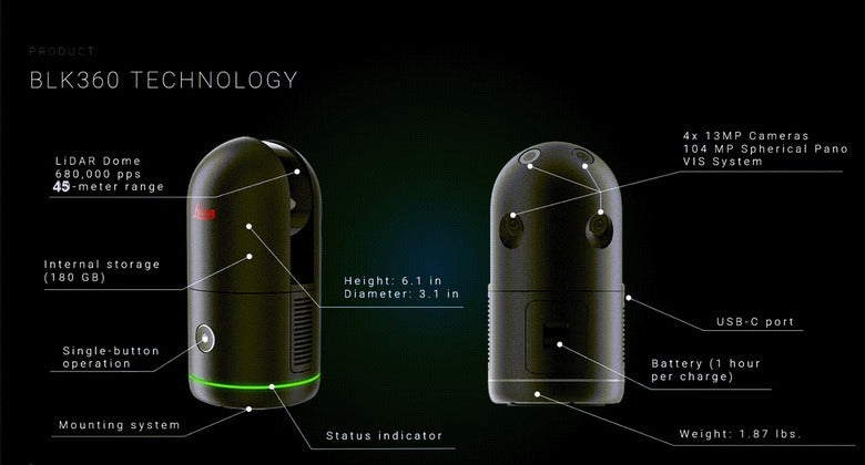
The all-new Leica BLK360 is an advanced precision imaging laser scanner. The BLK360 enables users to work faster and smarter while getting the data they need immediately.
Features:
- Four scan settings capture data in 7, 13, 30, or 75 seconds at 680,000 points per second
- Rich High-Dynamic Range (HDR) imagery with 5 bracket HDR
- Small and light, measuring 155x80mm and weighing just 850g with batteries
- Five times faster than the BLK360 G1, taking 20 seconds for a full-dome scan with photospheres
- Visual Inertial System (VIS) automatically pre-registers scans in the field
- High-speed data transfer via USB-C and Wi-Fi
The new BLK360 also makes it easy to get your data into your preferred software and to share your scans with others. Directly upload your data to HxDR with automatic conversion to OBJ and cloud-based visualization, allowing others to work with and download your data. Or transfer your data to Cyclone REGISTER 360 or export to E57 via USB-C or WLAN for Scan-to-BIM workflows.
General Specifications:
- Dimensions:
- Height: 166 mm (6.5 inches)
- Diameter: 102 mm (4 inches)
- Weight: 1.0 kg (2.2 lbs)
- Battery Life: Up to 2 hours per charge (depending on conditions and usage)
- Power Supply: 10.5 V rechargeable Li-ion battery
- Operating Temperature Range: 0°C to 40°C (32°F to 104°F)
- Storage Temperature: -10°C to 50°C (14°F to 122°F)
Scanning Performance:
- LiDAR Scanning Range:
- 0.6 m to 60 m (2 ft to 197 ft) range
- Accuracy:
- ±4 mm (0.16 inches) at 10 m (33 ft)
- Scan Speed:
- Scans a complete 360° environment in about 3 minutes for high-resolution scans
- Resolution:
- High-resolution point clouds with up to 1.3 million points per second
Imaging and Visual Data:
- Panoramic Images:
- 4 HDR (high dynamic range) cameras with a resolution of 1344 x 1344 pixels
- Full 360° imagery at 360° x 300° field of view
- Infrared Imaging:
- Optional, for thermal scans or capturing data in challenging lighting conditions
Connectivity:
- Wi-Fi: Built-in Wi-Fi for wireless connection to devices (for remote control and data transfer)
- App Control: Controlled via Leica Cyclone FIELD 360 app for iOS and Android devices
- USB Port: For data transfer via USB stick (directly to software for further processing)
Data Formats:
- Point Cloud Format: Leica’s native .e57, .las, and .pts formats are supported
- Panorama Image Formats: JPEG or PNG formats for panoramic images
- Data Compatibility: Works seamlessly with Leica Cyclone, Autodesk ReCap, Bentley products, and other 3D modeling/BIM software
Safety and Compliance:
- Laser Class: Class 1 (eye-safe)
- Environmental Protection: IP54 rating (dust and splash-resistant)
Software Integration:
- Leica Cyclone FIELD 360 App: For managing the scan process and visualizing results
- Leica Cyclone: For point cloud processing and data analysis
- Autodesk ReCap: Compatible for processing data into 3D models and CAD tools
- BIM Software: Compatible with multiple BIM tools for creating integrated designs
Additional Features:
- Real-Time Visualization: Live visualization of the scanned area on mobile devices during scanning
- Data Export: Direct export to CAD or 3D modeling software after scan processing
- GPS Integration: Option for GPS integration for georeferencing scan data in outdoor environments
- Simple Operation: No need for a computer to operate the scanner, everything is managed from a smartphone or tablet


Reviews
There are no reviews yet.