


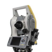
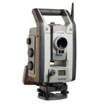
Leica Scanstation P16 3D Laser Scanner
The Leica ScanStation P16 is a high-performance 3D laser scanner used for capturing accurate, high-resolution 3D data for various applications in surveying, architecture, construction, engineering, and more. It is part of Leica Geosystems’ ScanStation series, known for their precision and versatility in the field of 3D laser scanning.
Features:
- High Accuracy & Precision:
- The P16 offers millimeter-level accuracy, typically within ±3 mm (0.1 in.) depending on the measurement range and conditions.
- It has a measurement range of up to 160 meters (525 feet) with single return mode, and up to 360 meters (1,181 feet) with multi-return mode, which is ideal for a variety of scanning needs.
- Fast Data Capture:
- With a scan rate of up to 1 million points per second, the P16 can quickly capture dense point clouds in less time than many other 3D scanners in its class.
- It offers fast and high-quality scanning for large-scale projects or environments with a lot of detail, such as buildings, construction sites, or complex industrial environments.
- Compact and Portable Design:
- The Leica ScanStation P16 is relatively lightweight and portable compared to other high-performance scanners, making it suitable for both indoor and outdoor applications.
- It can be mounted on a tripod or vehicle, providing flexibility for a range of scanning scenarios.
- Long Battery Life:
- Equipped with an internal rechargeable battery, the P16 allows for long-duration field scanning without needing constant power access. This is particularly useful for remote or outdoor applications.
- Advanced Imaging:
- Integrated with a high-quality digital camera, the P16 can capture colorized point clouds, adding photographic texture to the 3D model for better visualization and understanding of the scanned environment.
- IP54 Rating:
- The ScanStation P16 has an IP54 rating for dust and water resistance, ensuring durability and reliable operation in challenging environmental conditions such as rain, dust, or heat.
- Flexible Data Formats:
- The scanner supports a variety of data formats, making it compatible with most third-party software and hardware solutions in the 3D scanning ecosystem.
- It can generate point clouds in standard formats like .e57, .las, or .ptx, which are widely used in industry-standard software such as Leica Cyclone, AutoCAD, Revit, and other CAD and BIM platforms.
Applications:
The Leica ScanStation P16 is used in various fields including:
- Architecture and Engineering: For capturing detailed as-built models of existing structures, aiding in renovation, restoration, and facility management.
- Construction: For monitoring construction progress and creating accurate 3D models to identify potential issues.
- Industrial and Manufacturing: For capturing complex as-built environments such as factories or power plants.
- Surveying: For conducting geospatial surveys, topographic surveys, and site mapping with high precision.
- Cultural Heritage and Archaeology: Used for preserving and documenting historic sites, buildings, and artifacts in 3D.
Software Integration:
The ScanStation P16 integrates seamlessly with Leica Cyclone, which is Leica’s 3D point cloud processing software. It can also interface with other common point cloud processing and modeling software tools, enabling users to perform tasks such as:
- Point cloud registration
- Measurement and analysis
- Model creation for BIM (Building Information Modeling)
- Visualization and sharing of 3D data
Advantages:
- Efficiency: The ability to scan large areas quickly and accurately.
- Durability: Built to handle tough conditions in the field.
- Ease of Use: The user interface and software integration are designed for simplicity, making it easier for users to collect, process, and analyze data.
Limitations:
- Range: While the P16’s range is impressive, it may not be suitable for very large distances (e.g., beyond 360 meters) or large-scale mapping projects without using other scanning solutions.
- Resolution: For extremely fine detail at very short ranges, users might need to explore higher-resolution models like the P30 or P50, which are designed for more demanding applications.
Specifications:
| System Accuracy | |
| Accuracy of single measurement | Range accuracy: 1.2mm + 10ppm over full range Angular accuracy: 8″ horizontal; 8″ vertical 3D position accuracy: 3mm at 40m |
| Target acquisition | Up to 40m in post-processing software |
| Dual-axis compensator | Liquid sensor with real-time onboard compensation, selectable on/off, resolution 1″, dynamic range ±5′, accuracy 1.5″ |
| Distance Measurement System | |
| Type | Ultra-high speed time-of-flight enhanced by Waveform Digitizing (WFD) technology |
| Wavelength | 1550nm (invisible) / 658nm (visible) |
| Laser class | 1 (in accordance with IEC 60825:2014) |
| Beam divergence | <0.23mrad (FWHM, full angle) |
| Beam diameter at front window | ≤ 3.5mm (FWHM) |
| Range and reflectivity | Up to 40m; 18% reflectivity (minimum range 0.4m) |
| Scan rate | Up to 1’000’000 points per second |
| Range noise | 0.4mm rms at 10m 0.5mm rms at 40m |
| Field-of-View | Horizontal: 360° Vertical: 270° |
| Data storage capacity | 256GB internal solid-state drive (SSD) or external USB device |
| Communications/ Data transfer | Gigabit Ethernet, integrated Wireless LAN or USB 2.0 device |
| Onboard display | Touchscreen control with stylus, full color VGA graphic display (640×480 pixels) |
| Laser plummet | Laser class 1 (IEC 60825:2014) Centering accuracy: 1.5mm at 1.5m Laser dot diameter: 2.5mm at 1.5m Selectable ON/OFF |
| Imaging System | |
| Internal camera | Resolution: Pixel size: Video: White balancing: HDR: |
| External camera | Canon EOS 60D and 70D supported |


Reviews
There are no reviews yet.